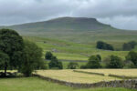
The Walter Morrison Way – Coniston Cold to Giggleswick Walk
Walter Morrison helped shaped the Western Dales. The philanthropist built and restored schools, places of worship, barns, inns and housing for estate and factory workers. He campaigned for education and universal voting rights, yet today his name is almost forgotten. A new festival in his name aims to change that – and this thrilling 17-mile walk retraces some of Morrison’s favourite paths and connects some of the landmarks in Malhamdale and Craven.
The Walter Morrison Way starts at the bus stop at Coniston Cold Old Post Office. If you have parked in Settle, the bus trip from the Market Place takes about 23 minutes. If you have driven to the start, please park responsibly. Cross to the north side of the A65 and on to a small lane. After a short distance, you will pass St Peter’s Church on your L. The lane continues under the railway and the River Aire will be on your R until you reach Red Bridge. At the bridge, take the road L into Bell Busk. A little way along the road, you will come to the entrance to the Old Station.
Opposite the Old Station, take the Bridleway along the side of Raven Flatt Barn towards Airton, through a gate and over a stone bridge along Kirk Syke Lane, Near a barn is a wooden FP sign ‘Keep to Fence Side’. Keep the fence on your L and ascend the field, Pass through a gate with a boulder in front of it. Keep the fence on your R, Pass a barn and, at the junction of tracks at Kirk Syke Farm, turn L. As you see Airton village ahead, take the R footpath at a house marked ‘Eshton Road 150 yds” and continue to the main road in the village at Tatum Barn. At the main road, turn L.
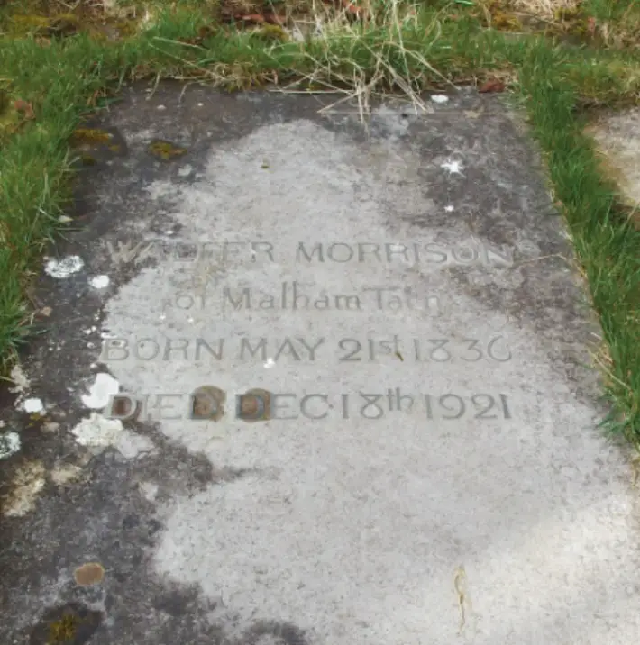
The simple headstone of Walter Morrison in Kirkby Malham Church
image: Malcolm Kirton
“Descending steeply”
Follow the road out of the village past the church. Ignore a FP on the R to Malham. About 1/3 mile out of the village, take a FP L to Warber Hill. Continue across several fields keeping a lookout for a FP sign to ‘Kirkby Malham’. Beyond a gate stile, you will see a FP sign in a field, Head for this and the second sign beyond, across the summit of the bank. Go straight ahead towards a small copse as the path begins to descend. You will see Kirkby Malham Church in the valley below, Head for the church, descending steeply through a gate in a fence and down wooden then stone steps (which can be slippery in wet weather). Cross the footbridge and enter the churchyard.
After visiting the church, leave by the South Door and turn left on to the track past the Victoria public house (built in 1840; there is a fine sundial over the front door). Kirkby Malham Parish Hall is on the opposite side of the road, Turn L and follow the road out of the village. Ignore the FP signs on the R to Malham but stay on the road until you reach a FP sign “Malham 3 ML’ on the L. Follow this path and pass through several gated stiles. You will see Kirkby-in-Malhamdale School on the R. Pause near the New Friars Garth Farm to admire the view of Malham and Malham Cove. Beyond the school, cross a gravel track leading to a farm which is on your L. Keep ahead and slightly R and descend the field and cross a wall stile on to the road into Malham before you reach the stream at the bottom of the field.
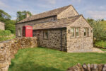
Continue L on the road into Malham, passing the Buck Inn on your L. At the crossroads, take the road L up Cove Road, Ignore all FP signs until you reach Town Head Farm, the last farm on the left. In the yard to the R of the farmhouse, there is a barn built by Walter Morrison in 1865. This is private property so please view the barn from the road.
Continue up the road to a FP sign on L marked ‘Long Lane’. Follow the footpath uphill towards a wall stile next to a yellow topped post, There are ‘good views of Malham Cove to R. Just beyond is Cowgill Barn (built by Walter Morrison in 1865).
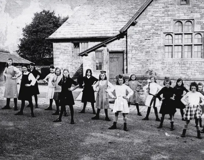
Kirkby-in-Malhamdale Primary School
image: Malhamdale Local History Group
“Limestone track”
At the barn, continue directly uphill to a wall stile which leads directly into Long Lane, an old track between two walls. Turn R along the lane at the end of which is a gate, Go through this and continue for about 30 metres then fork R to a gate leading on to the road. Turn R down the road and then L at a FP signposted ‘Dean Moor 1 ML’.
Don’t lose height, but continue along the FP gradually uphill. Look for a rock with 2 yellow FP markers on it and aladder stile beyond, Go over a stone stile in the wall and on to another gated stile across Ewe Moor (National Trust). Note the fine limestone pavement on your L. Continue until you reach a FP signposted ‘Langscar Gate’ to L. Do not turn L here but cross the ladder stile in the wall to R and then turn L up the grassy bank, Continue to a FP sign ‘Public Bridleway Malham Tarn 3 ML’. Take this path which eventually descends towards the road, Pass though a gate and turn R on to the road, though a gate to the small car park on L.
At the car park, follow the Pennine Way sign ‘Malham Tarn 4 ML’. Here you will have your first view of Malham Tarn House, Morrison’s, ‘Mountain Home’. There are several paths heading towards Malham Tarn, Don’t go too close to the shore but head to R of a wall enclosing trees, Beyond this walled copse, and between two further groups of trees, you will see a gate on a limestone track at a National Trust sign ‘Malham Tarn Estate’. Follow the track to a gate into a wood. On the top of a bank in the wood you will reach Malham Tarn House.
Pass to the rear of the house (where there is an information panel about Walter Morrison) and down through a rock cutting. There are splendid views across the Tarn to your L. Continue on the track past several estate buildings. At Smithy Barn, turn L down a track by a post box in the wall. Look out for Exmoor ponies grazing the rough grass of Malham Tarn Fen. The Exmoor pony is Britain’s oldest breed of native pony and thought to be little different from the original wild ponies that colonised Britain thousands of years ago. Follow this track and pass through the gate L on to the road, When the road forks, take the L turn up a bank towards High Trenhouse. This building, now the home of the Centre for Management Creativity, is another Morrison house.
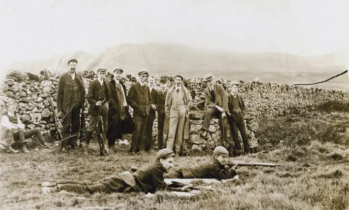
Attermire Rifle Range
image: Museum of North Craven Life
“Deeply-rutted path”
At the crossroads cross the stile to R of National Trust ‘Malham Tarn Estate’ sign and take the footpath ‘Public Bridleway Langeliffe 4 MI’. The path continues slightly to the R, joins a broader path and descends to a ford over a stream, Take care crossing the ford and head directly up the deeply-rutted path beyond, The path now becomes very indistinct. Keep slightly R uphill and pass over a low, broken wall to a second complete wall with a small gate with a ladder stile to its R, Go through the gate and follow the track straight ahead until it joins the much clearer track of the Pennine Bridleway, keep right and continue to a gate and ladder stile, To your R, there are now fine views of the famous Yorkshire Three Peaks (from L to R, Ingleborough (723 m), Whernside (736 m), Pen-y-ghent (694m).
Continue on the Pennine Bridleway for about 1.75 miles until you descend to a sign, immediately before a gate, L to Victoria Cave. Take this path which follows the wall to your R and the escarpment to your L. If you wish to visit Victoria Cave, then, after about 0.25 mile, take a smaller rough path which leads up to the L. Victoria Cave is not visible from the main path, The National Park advise that roof falls are possible, Please take care if you enter the cave. After visiting the cave, drop back down and turn L on to the main path. The large flat area directly ahead and below you is Attermire. On a clear day, you can see Pendle Hill in Lancashire (about 20 miles away) and to R, the Warrendale Knotts.
As the path begins to descend, take a gate in the wall to R and drop steeply down a stony path on to a broader track, Turn R on to this track. Soon you will pass the remains of the Rifle Range.
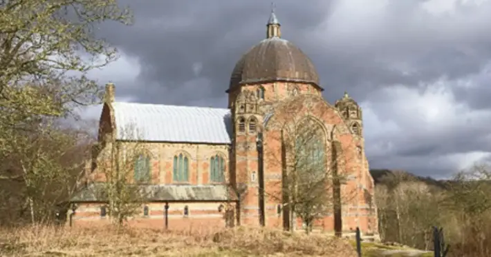
Giggleswick School Chapel
image: Brayshaw Archive and Giggleswick School
“Fast-flowing”
Just beyond the Rifle Range, you will see a signpost over a wall on the L. Do not cross the wall stile here but continue straight ahead keeping the wall on your L. The path rises and at the top of the bank. You will see a small cave on the R, Stay on the wider L path closer to the wall. Soon you will see Settle in the valley below. Look for the viaduct of the famous Settle to Carlisle Railway and, on the slope behind, the domed Giggleswick School Chapel, our destination and, in the far distance, the hills of the Forest of Bowland, Looking R, you can see two 19th century mills on the banks of the fast-flowing River Ribble.
Stay on the path which drops steeply to re-join the Pennine Bridleway. Turn L. The track drops steadily down to L to Constitution Hill and into Settle, At the fork at the Old Brewhouse, turn L at the National Trust acorn sign marked ‘PEW’.
Continue in the same direction along Castlebergh Lane past the Drill Hall and a short way along on your R take the path down Well Hill, At the bottom you will see the ‘Well’ of the name and the steps leading back up to Castlebergh Lane.
Settle Drill Hall
image: Lynn Northrop
“Blue plaque”
Go up the steps and turn R along Castlebergh Lane, After about 300 metres, on the L is Zion Chapel.
Take the tarmac steps down on the R opposite the Zion Chapel and then turn R to come to The Folly.
From the front of The Folly, follow Chapel Street towards the main road. Cross the road at the pedestrian crossing and turn R. Ata blue signpost marked ‘Friends’ Meeting House’ turn L onto Kirkgate towards Victoria Hall, Continue on Kirkgate and, after 30 yards on R at the former Spread Eagle Inn, see the blue plaque for Thomas Procter (1753-1794). A few yards further on the Ris the Victoria Hall.
Continue on the road under the railway bridge, cross over to L (there is no pavement on R) and carry on downhill past Settle Cricket Club on R and Booths supermarket on L. Turn left in front of the Fire Station along a footpath signposted ‘River Ribble.’ At the end of the footpath, follow the road to R, Before you reach Riverside View, turn Lat a blue and white sign (‘Cyclists Dismount’) and cross the River Ribble by Giggleswick Memorial Bridge.
The gap stile
image: Clive Lane
“Flaming corona”
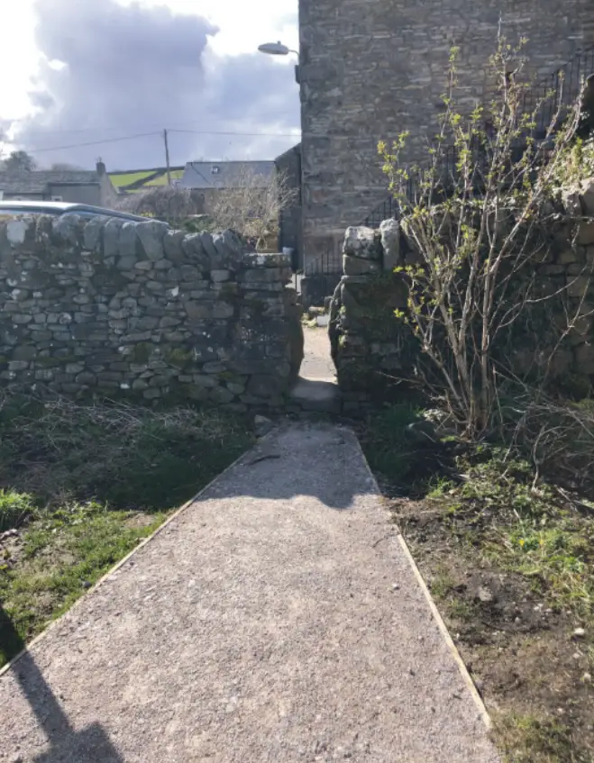
Go over the bridge and at the blue footpath sign, turn L then immediately R up the slope, Follow the narrow path between two high stone walls towards Bankwell Road. At the road, turn L then R at the bus shelter on to the Harrison Playing Fields, Follow the path with the children’s playground on your R and then directly through two stones forming a gap stile in the wall to the back of houses on Tems Side, Follow the narrow lane and cross the small bridge over the stream. Turn R with the stream on R and turn L at the next small bridge up Bucks Lane and turn R onto Raines Road.
Go along Raines Lane and at the junction with Church St turn L (Signposted ‘Giggleswick School’), At the next junction (follow the school sign, ‘Senior School Reception’) continue steeply up Craven Bank Lane. At the top of the bank, pass through the Lodge. Follow the footpath to Giggleswick School Chapel with the cricket field on R.
About 150 yards along a path at the back of the Chapel is a stone marking the spot where the Astronomer Royal, Sir Frank Dyson FRS, had an uninterrupted view of the flaming corona of the sun during the 23 seconds of its total eclipse on 29 June 1927.
Visits to the chapel can be arranged by contacting the school’s reception on 01729 893 000.
For more info on the Walter Morrison Festival visit: thefolly.org.uk