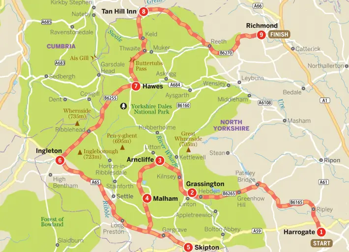
The Perfect Yorkshire Dales Road Trip
This roller coaster of a route leads you through the finest scenery in the Yorkshire Dales, from pretty villages and country pubs to limestone crags and windswept moors.
The winding road over the Buttertubs Pass – a favourite of TV motoring programmes and a highlight of the Yorkshire grand départ of 2014’s Tour de France cycling race – is regularly voted the most spectacular road in England. This trip adds a second thrilling road climb, from Arncliffe to Malham, to link six of the national park’s most beautiful dales in a tour de force of scenic splendour.
1. Harrogate
The quintessential Victorian spa town, prim and pretty Harrogate has longbeen associated with a kind of old-fashioned Englishness – it is fitting that the town’s most famous visitor was crime novelist Agatha Christie, who fled here incognito in 1926 to escape her broken marriage. It was also Queen Victoria’s favourite spot for a spa break. Wander around the Montpellier Quarter, an area of pedestrianised streets lined with restored 19th-century buildings that are now home to art galleries, antique shops, fashion boutiques, cafes and restaurants, and learn all about the town’s history in the ornate Royal Pump Room Museum, built in 1842 over the most famous of the town’s sulphurous springs. If you feel like sampling the waters for yourself, take a dip in the town’s ornate Turkish Baths, a Victorian’s idea of a Moorish bathhouse. A range of watery delights are on offer here: hot rooms, steam rooms, a plunge pool and so on, plus use of the original wooden changing cubicles and historic Crapper toilets. Opening hours are quite complex (bathing sessions are alternately mixed and single sex) – check the website for details. There’s also a fascinating guided tour of the building (9am Monday, Wednesday and Friday).
The Drive
Head north out of Harrogate on the A61. After 4 miles turn left at Ripley onto the B6165 to the pretty town of Pateley Bridge, then continue on the B6265 as it climbs high over Craven Moor before entering the Yorkshire Dales National Park and descending to Grassington (total 24 miles).
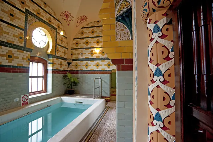
Arabessque interior of Harrogate Baths
Pete Seaward/ Lonely Planet
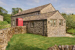
2. Grassington
The perfect base for hiking the south Dales, Grassington’s handsome Georgian centre teems with walkers and visitors throughout the summer months, soaking up an atmosphere that – despite the odd touch of faux rusticity – is as attractive and traditional as you’ll find in these parts.
The Drive
Head north out of Grassington and follow the B6160 along Wharfedale for a few miles. Soon after passing the massive limestone overhang of Kilnsey Crag on your left, take the minor road on the left to Arncliffe, just 8 miles from Grassington. As you enter the village turn left to find the village green.
3. Arncliffe
The tiny village of Arncliffe sits in the heart of scenic Littondale, its neat stone houses ranged around the village green. On the north side of the green is the Falcon Inn, the original for the Woolpack pub in Emmerdale. It’s a lovely rustic inn where beer is still served from a jug on the counter.
The Drive
Exit the far end of the village green, cross the bridge and turn sharp left to follow the steep, twisting, single-track road that climbs up the valley of Cowside Beck (beware of wandering sheep). At a fork near Malham Tarn bear left and after 400m, at another junction, continue straight across and descend steeply into Malham (9 miles).
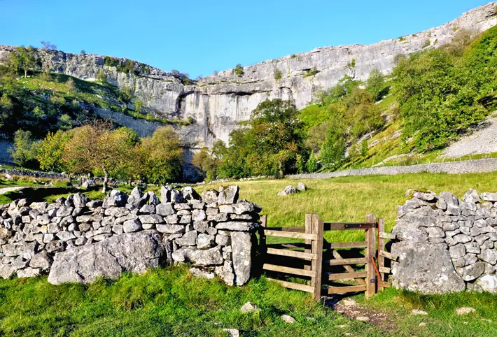
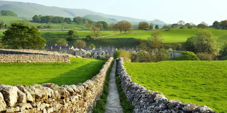
Stone fence at Malham Cove in Yorkshire Dales
albinoni/ shutterstock
4. Malham
Malham is set within the largest area of limestone country in England, stretching west from Grassington to Ingleton – a distinctive landscape pockmarked with potholes, dry valleys, limestone pavements and gorges. Two of the most spectacular features – Malham Cove and Gordale Scar – are within walking distance of Malham’s centre. The huge rock amphitheatre known as Malham Cove is ringed with 80m-high vertical cliffs. In the wake of the last Ice Age, this was a waterfall to rival Niagara; today it is a playground for rock climbers. Peregrine falcons nest here in spring, when the RSPB sets up a birdwatching lookout. You can hike up the steep steps on the left-hand side of the cove to see the extensive limestone pavement above the cliffs.
For a longer walk, follow the 5-mile circular Malham Landscape Trail which continues on to spectacular Gordale Scar, a deep limestone canyon with scenic cascades, then leads to the remains of an Iron Age settlement and Janet’s Foss waterfall.
The Drive
Continue south on the minor road from Malham (it can be very busy on summer weekends) to the A65, and turn left to reach Skipton in 11 miles.
5. Skipton
This busy market town on the southern edge of the Dales takes its name from the Anglo-Saxon sceape ton (sheep town) – no prizes for guessing how it made its money. Skipton’s pride and joy is the broad and bustling High Street, one of the most attractive shopping streets in Yorkshire. Monday, Wednesday, Friday and Saturday are market days, bringing crowds from all over and giving the town something of a festive atmosphere. No visit to Skipton is complete without a cruise along the Leeds–Liverpool Canal, which runs through the middle of town. Pennine Cruisers runs half-hour trips to Skipton Castle and back.
The Drive
Head northwest from Skipton along the A59 onto the busy A65, and continue to Ingleton, 24 miles away. Turn off the main road and follow signs for Village Centre, and then Waterfalls Walk.
6. Ingleton
The village of Ingleton, perched precariously above a river gorge, is the caving capital of England. It sits at the foot of one of the country’s most extensive areas of limestone, crowned by the dominating peak of Ingleborough and riddled with countless potholes and cave systems. The town is the starting point for a famous Dales hike, the circular, 4.5-mile Waterfalls Trail, which passes through native oak woodland on its way past a series of spectacular waterfalls on the Rivers Twiss and Doe (allow three to four hours).
The Drive
Follow the B6255 northeast from Ingleton. Beyond Chapel-le-Dale you’ll see the spectacular 30m-high, 400m-long Ribblehead Viaduct on your left. The road continues over bleak Gayle Moor and down to Hawes (17 miles). Leave the car in the car park beside the national park centre at the eastern end of the village.
7. Hawes
Hawes is the beating heart of Wensleydale, and a thriving and picturesque market town (market day is Tuesday) with several antique, art and craft shops, with the added attraction of its own waterfall in the village centre. Beside the car park is the Dales Countryside Museum, a beautifully presented social history of the area that explains the forces shaping the landscape, from geology to lead mining to land enclosure. At the other end of the town is the Wensleydale Creamery, devoted to the production of the animated TV characters Wallace and Gromit’s favourite crumbly white cheese. You can drop into the visitor centre, watch cheesemakers in action, and then try-before-you-buy in the shop. There’s also a rather good cafe, Calvert’s Restaurant.
About 1.5 miles north of Hawes is 30m-high Hardraw Force, the highest unbroken waterfall in England, but by international standards not that impressive (except after heavy rain). Access is via a lovely landscaped walk (400m) from the car park behind the Green Dragon Inn. There’s an admission fee (coins only) to access the walk, and a cafe selling local ice cream.
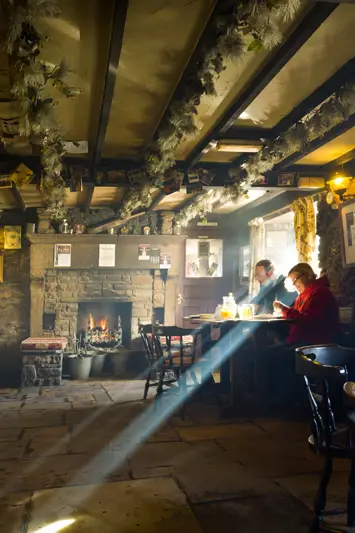
Patrons inside Tan Hill Inn, Swaledale
Justin Foulkes/ Lonely Planet
The Drive
The 13-mile route from Hawes to the Tan Hill Inn is one of the most scenic in the Dales. Turn right and right again out of the car park (signposted Muker) and follow the minor road over the Buttertubs Pass. Turn left on the B6270 to Keld, then right on the minor road signposted West Stonesdale and Tan Hill.
8. Tan Hill Inn
Sitting in the middle of nowhere at an elevation of 528m (1732ft), the Tan Hill Inn is Britain’s highest pub. Despite its isolation it’s an unexpectedly comfortable and welcoming hostelry, with an ancient fireplace in the atmospheric, stone-flagged public bar, and an assorted menagerie of dogs, cats and even sheep wandering in and out of the building. An important watering hole on the Pennine Way, the inn offers real ale on tap and decent pub grub.
The Drive
Head east from Tan Hill on a wild and lonely single-track road that cuts across the high Pennine moors then descends through Arkengarthdale to the picturesque village of Reeth. Follow the B6270 along Swaledale through classic Dales scenery patchworked with drystone dykes and little barns, then the A6108 for the final stretch to Richmond (total 23 miles).
9. Richmond
The handsome market town of Richmond is one of England’s best-kept secrets, perched on a rocky outcrop overlooking the River Swale and guarded by the ruins of massive Richmond Castle. A maze of cobbled streets radiates from the broad, sloping market square (market day is Saturday), lined with elegant Georgian buildings and photogenic stone cottages, with glimpses of the surrounding hills and dales peeking through the gaps. It’s a fine spot to end your Yorkshire adventure.
Another important Richmond landmark is the Georgian Theatre Royal. Built in 1788, this is the most complete Georgian playhouse in Britain. It closed in 1848 and was used as an auction house into the early 20th century, reopening as a working theatre again in 1963 after a period of restoration. Fascinating tours (starting on the hour) include a look at the country’s oldest surviving stage scenery, painted between 1818 and 1836.
Lonely Planet Great Britain’s Best Trips 2nd Ed UK ₤15.99 – available where all good books are sold
Top image: Sedber Lane, Grassington, Wharfedale, Yorkshire Dales National Park, albinono/ shutterstock