Circular Walk Along the River Wharfe, Starting in Grassington
By Johno Ellison
The River Wharfe rises high in the Yorkshire Dales and flows through some of the National Park’s most stunning scenery. This walk covers a circular 6.5-mile route beginning in Grassington, the hub of Upper Wharfedale, and taking in some of the prettiest villages of Dales, before looping around back to the start.
Grassington is quite well connected to public transport, with fairly regular buses from Leeds and Skipton, or is also easy to reach by car. The walk begins from the National Park Visitor Centre in Grassington, which also serves as the dropoff point for buses and has ample parking.
From the Visitor Centre, it’s a short, 200-metre stroll into the centre of town, if you require any last-minute supplies, but if not, instead turn right out of the car park, then immediately turn right again, to head down Sedber Lane towards the river.
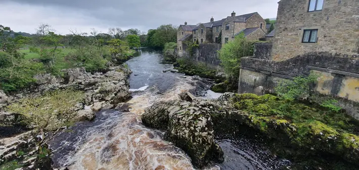
After about 150 metres a small, walled path veers off the residential cul-de-sac, and another 300 metres takes us towards the roar of Linton Falls, the largest drop of water along the River Wharfe. Depending on the recent weather your impression of the falls here may vary. During low water, in summer time, visitors will be happy to cross the footbridge that was originally built so weavers in the former mill on the far bank of the river could get to work.
Halfway over the bridge you might stop to peer over the railing at the peaty water cascading through the maze of rocks.
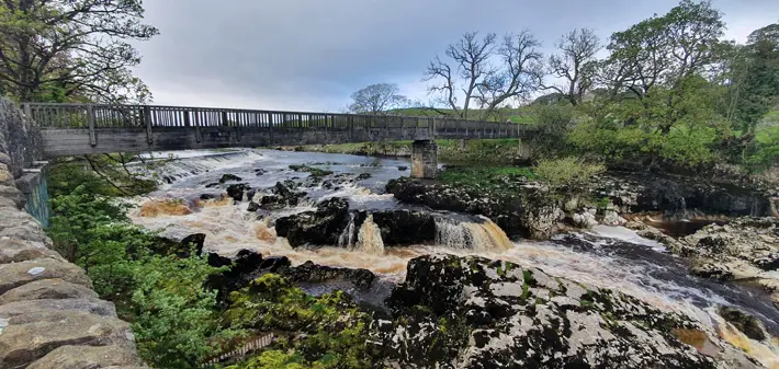
Linton Falls – the highest drop on the River Wharfe
“Lovely avenue of mature trees”
However, after heavy rains the falls can turn into a raging torrent and the sturdy centre-support of the footbridge – which normally looks so firmly anchored to a rocky outcrop – quickly disappears beneath the frothing roil. At times like this visitors are more likely to quickly rush across the bridge, holding their breath until the safety of the opposite bank, or perhaps even forgo stepping on the bridge, leaving it for braver – or more foolhardy, depending on your view – souls.
From Linton Falls, follow the river east, using the path on the lefthand bank as you look downstream. The pleasant footpath underfoot forms part of the longer Dales Way. This is an 80 mile long distance route starting in Ilkley and mostly following the Wharfe, before leaving Yorkshire at the very head of the river, and continuing onwards to the Lake District, finishing at Lake Windermere.
Back on the riverbank, the path takes us to a lazy righthand bend in the river, with the church of St. Michael’s & All Angels visible on the other side. If the water is low here you can pop over the stepping stones to see the church, which is unusual in that it doesn’t feature a tower or steeple, being marked simply as a cross on the Ordnance Survey map.
In times past the parson here had quite a reputation as a dancer, and he often engaged the services of local fiddlers to provide him with music so he could practise his steps. But, the parson was rather self conscious, either about his pastime, or his moves, and so whenever he hired musicians he ordered them to play with their backs turned.
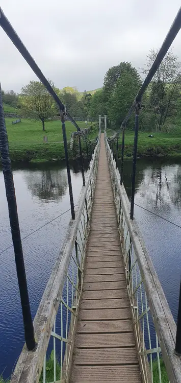
Hebden Suspension Beidge
However, Leeds historian Edmund Bogg notes that on one occasion the lure of the parson’s jig was irresistible, and one of the fiddlers sneaked a glance over their shoulder. Unfortunately for him, the eagle-eyed man of god spotted the musician’s impudence in the mirror, and, ‘without time for apology he was kicked to the door.’
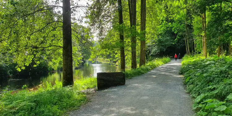
Continue to follow the river downstream for about a mile, through a lovely avenue of mature trees. In the spring this stretch abounds with swifts skimming the water’s surface, while the occasional curlew also labours across the scene, flapping madly, far above.
“Ivy-covered pub”
The footpath now leads us to the unmistakable profile of Hebden suspension bridge, made by a local blacksmith, financed by public subscription from nearby villagers after one of their number was swept away while crossing the nearby stepping stones way back in 1885.
These days, the bridge is showing its age a little but it still faithfully carries many walkers every day.
We’re now on the righthand bank of the river, approaching Burnsall, but first the raised fold of land called Loup Scar rears out of the fields. Here, the river has carved a small cliff from the elevated rock, exposing the strata and sheltering a popular swimming spot for paddlers on sunny days, or more adventurous wild swimmers all year around.
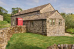
Beyond Loup Scar the river winds to the right, bringing us into one of the prettiest villages of the Dales – Burnsall – with its ivy-covered pub, grand bridge and cosy-looking cottages with perfect flowerbeds.
This village marks a rough halfway-point and refreshments can be had at the Red Lion pub, or at the Tea Rooms over the road. Between the two Burnsall’s maypole takes pride of place, topped with a pair of leaping salmon – more on that later.
If you’re feeling particularly spritely here, you could continue downstream, following the river to reach the stunning Bolton Abbey estate – which includes one of the largest stands of oaks in the Dales and is also home to the Strid, a narrow chasm notorious for being one of the most deadly stretches of river anywhere in the world, where the entire force of the Wharfe rushes through a rocky gap little over two metres wide.
Burnsall – viewed from further downstream
“Walled track”
When you’re ready to continue, head into Burnsall village, following the road around the sharp right-hand corner, then keep an eye out for the footpath on the left, squeezed between the wall and a cottage. This path takes us over the fields, behind the houses of Burnsall, gently rising until we reach a rough track known as Badger Lane. Cross directly over the track and then continue following the footpath through the fields, crossing a small beck, then following the wall before passing a small wood. The footpath will bear right slightly, and in the corner of the field it becomes a walled track which leads along to a tiny B-road called Kail Lane. Turn left along the road, going past the farm and down into the hamlet of Thorpe.
Here you can take a breather at the triangular village green and consider some of the history of the small village. Thorpe was previously a village of shoemakers, as well as being a friendly rival to the more well-known Burnsall. However, history records that one day, back in 1804 the people of Burnsall awoke to find that their prized maypole was nowhere to be seen. The outraged villagers mounted a search and before long the missing pole was discovered here in nearby Thorpe.
Although the Thorpians were tight-lipped, their unimpressed neighbours were having none of it. According to the writing of Edmund Bogg, the Burnsallians raised a small crowd, ‘thrashed the cobblers, and carried back the Maypole to its original position.’
This story was little more than a historical footnote until another May rolled around, almost 200 years later. In spring 1991 preparations for another May Day were underway when, once again, Burnsall’s maypole disappeared. Like before, a search found the pole in Thorpe, this time concreted in. Yet again, the people of Thorpe claimed that they were none the wiser, with one local sheep farmer telling the Craven Herald newspaper that he hadn’t seen anything suspicious but that he quite liked the new addition.
“Down into the valley”
And so, once again, the residents of Burnsall returned to Thorpe, this time along with a tractor and ropes, to retrieve their property. The newspaper didn’t record whether any ‘thrashings’ took place on this later occasion.
Pass through Thorpe and continue along Kail Lane, now heading slightly uphill, to exit the village. Once the houses begin to peter out, take the lefthand turning up Thorpe Lane. Although we’re now walking on backroads, these are so quiet that you almost feel like you have your own private footpath.
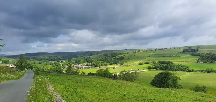
The road rises over the crest, giving great views down to the right, along the Wharfedale. About 700 metres, or half a mile, after the turn off, you’ll see a footpath flanked by two walls on the right – this isn’t quite our turn off – we’ll continue another hundred metres to a path on the right, with a small stile with a wooden gate. This takes us off down into the valley, over the fields down towards Linton, the village that gives its name to the falls we saw near the start of the walk.
As we head down the hill, the footpath turns into a track which takes us into the village. This is actually the second Linton on the river, with another about thirty miles downstream near Collingham, and at least three further Lintons in Yorkshire alone. That the name is so common is probably down to the former prevalence of flax, also known as linseed, which was popular in textiles before cotton took over.
Follow the track into the centre of Linton and an excellent village scene unfolds, with all of the makings of a postcard. There’s the babbling Linton Beck, crossed by an attractive humpback bridge, a red phonebox and a whitewashed Dales pub. On the other side of the beck, next to the pub, we can also see a grand stone building known as the Fountaine Hospital.
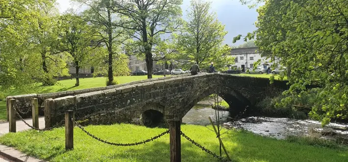
The bridge over Linton Beck
“Rest by the beck”
This was built as an almshouse in the 1720s, using money bequeathed by Richard Fountaine, a wealthy son of Linton who had made his fortune in London. Stories swirl around Richard and his legacy. Some say his riches were earned when an episode of plague struck London, as he was a coffin maker, but this actually seems to be a rumour started by a fanciful historian in the 1920s. The true source of Richard’s wealth appears to have been his more down-to-earth haberdashery business.
Other rumours say that Mr Fountaine’s descendents were thrown into uproar when they learned that a chunk of their inheritance would be used to construct and run the almshouse – a type of charitable housing that was provided to look after poor and sick people in the local community. In the case of Fountaine’s Hospital here, an investment and instructions were given, to care for six local residents.
At Linton you can rest by the beck, or enjoy some food or drink in the Fountaine Inn, before following Lauradale Lane (turn left as you exit the pub’s front door, then right onto the main road) out of the village, over a small rise, with the high retaining wall on your right. At the crossroads continue straight over the junction and follow Church Road down the hill.
Linton Falls – looking downstream
“Roar of the river”
At the bottom of the hill, peel off the left (where the road sharply turns right) and this short path then takes us back to Linton Falls, near where we began our walk. Looking upstream the Linton Falls Hydro station can be seen. This small power station provided Grassington with electricity for almost forty years, from 1909 up until the arrival of the National Grid in 1948. It then stood derelict for many years but was modernised and returned to duty in 2011, now generating enough power for ninety nearby homes.
To return to the starting point, simply cross the footbridge at Linton Falls, taking in the roar of the River Wharfe for one last time, then head back up Sedber Lane, to the Visitor Centre.
Johno Ellison is the author of ‘Walking the Wharfe: An Ode to a Yorkshire River’ – published by Bradt Guides, 10th August 2023
All images courtesy of Johno Ellison